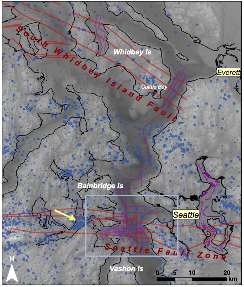
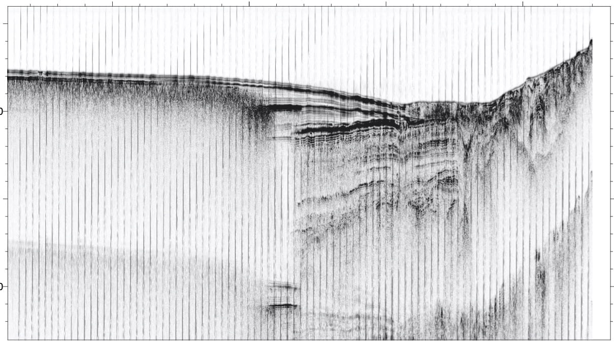
Crustal faulting in the Puget Lowland
Perched on the edge of a convergent plate boundary, the Pacific Northwest hosts many kinds of active fault zones. In Puget Sound, regional stresses are accommodated on thrust and strike slip faults that allow for deformation within the North America plate; these faults which are not located directly at the plate boundary are termed “crustal faults”. Although these faults will likely not generate earthquakes as large as the Cascadia Subduction zone, they are located close to population centers and may produce relatively shallow earthquakes, possibly as large a magnitude 7. Our group is using diverse geologic and geophysical datasets, including marine seismic reflection profiling (like the CHIRP profile shown above) to refine our understanding of the location, deformation patterns, and 3D geometry of crustal faults including the Seattle Fault Zone and South Whidbey Island Fault. This work is being done in collaboration with researchers at UW (Ginevra Moore, UW Ocean, Juliette Crider and Elizabeth Davis, UW ESS), and the USGS (Scott Bennett and Janet Watt) and has been supported by grants from the USGS National Earthquake Hazard Reduction Program (NEHRP). Recent BSSA Article by Moore, Roland et al., 2022. Figures: Map of Puget Sound region next to example CHIRP profile – (y-axis is two way travel time, similar to depth in the earth). Crustal Faults from the USGS Fault and Fold database (red on map) as well as new seismic data collected to image subsurface faulting patters in 2017 (purple).
Submarine Landslides in Alaska Fjords

In Alaska fjords, local tsunamis have caused significant damage and loss of life when they are generated by landslides, often triggered by large earthquakes. Landslide events associated with the 1964 Great Alaska earthquake (magnitude 9.2, second largest earthquake recorded on earth) leave an expression in the seafloor morphology within Alaska fjords in Wittier, Seward, Valdez and many others. Older landslides associated with prehistoric earthquakes can also be identified in the subbottom structure as distinct landslide deposits. These modern and old sediment packages contain information on both the nature of submarine landslides and the tsunamis that they may have triggered, as well as past large earthquakes that may have initiated the mass movement events. We use geophysical data including marine seismic reflection and multibeam bathymetry, as well as information on timing from cores to characterize the history and physical processes that influence submarine landslides in these settings. This has potential implications for tracking relationships between submarine landslides, climactic and glacial conditions, and earthquakes to gain a better understanding of multi-hazards in this region. This work is done in collaboration with colleagues in the USGS (Peter Haeussler, Tom Parsons, and Pat Hart). 2020 Paper on Submarine Landslides in Port Valdez Alaska. Figure: Isopach maps shows the thickness of landslide deposits (red is ~40m) imaged beneath the fjord floor associated with the 1964 submarine landslide, which was triggered by the M9.2 Great Alaska Earthquake.
Subduction Zone Earthquakes in Alaska
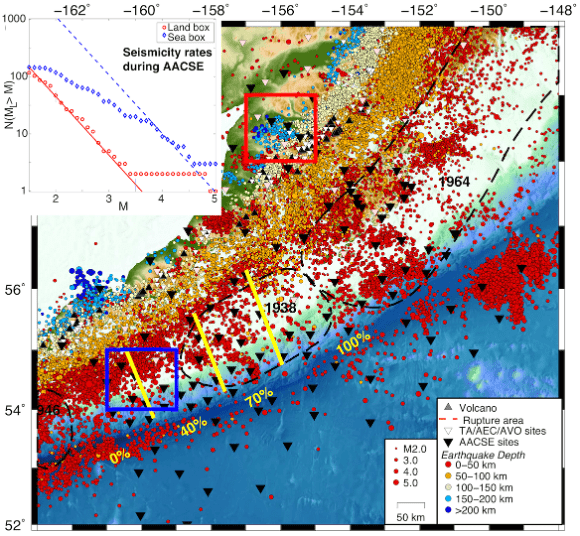

The Alaska-Aleutian subduction zone is one of the most prolific megathrust systems in the world. It has hosted several great earthquakes in the past ~100 years and also demonstrates striking changes in mechanical behavior along-strike. In the past few years it has also been the focus of an unprecedented amphibious community seismic experiment to explore 1. variability in slip behavior and seismicity along the subduction zone megathrust, 2. material and volatile cycling and 3. large-scale dynamics of the Alaska subduction zone. Our group is using new seismic observations in Alaska to explore fault characteristics across the Alaska Peninsula segment. In particular, we are interested in exploring upper plate faulting. We are also looking at how small-scale seismicity changes across a theorized transition in plate boundary locking, where the margin evolves from the interseismically locked Semidi segment to the region of proposed aseismic strain release in the “Shumigan Gap”. To do this, we rely on earthquake observations recorded on land and on Ocean Bottom Seismometers deployed as a part of the Alaska Amphibious Community Seismic Experiment across the Alaska forearc and over the Pacific plate. With this data, we hope to constrain the geometry and extent of earthquake nucleation, the down-dip extent to which thrust faulting takes place and the patchiness of deformation, and to connect these observations with the physical nature of the interface from active- and passive-source imaging. This work is in collaboration with a huge team of AACSE PIs. Research in our lab is currently being supported by a NSF-GeoPRISMS grant with co-PIs Geoff Abers (Cornel) and Susan Schwartz (UCSC.) AACSE EOS Article by Geoff Abers and AACSE Team; Data highlights SRL Article by Grace Barcheck et al. Figures: Map of earthquakes in AEC/USGS catalog with M≥2.0 for 1999-2018. Yellow lines show geodetic locking segment boundaries (Li & Freymueller, 2018). Seismograms recorded on an AACSE land station (available in the IRIS DMC). Three magnitude 3-4 earthquakes occurred in 2018 during a 10-minute interval, as a part of an apparent swarm ~100 km offshore within the Semidi segment.
Transpressional Tectonics – The Queen Charlotte Fault


The Queen Charlotte Fault forms a transpressional plate boundary (transform with some compressional component), on par with other major transform fault systems in terms of slip rates and seismogenic potential (i.e. San Andreas, Alpine Fault). This boundary between the Pacific and North American tectonic plates offshore western Canada and Southeast Alaska sustains the highest known deformation rates among continental or continent-ocean transform systems globally, accommodating >50 mm/yr dextral offset. The entire ~900 km offshore length has ruptured in seven >M7 events during the last century, making the cumulative historical moment release higher than any other modern transform plate boundary system. Along with a team of collaborators (Lindsay Worthington (UNM), Maureen Walton (USGS), and Maladen Nedimovic (Dalhousie), as well as others from the USGS and Geological Survey of Canada) we will be engaged in a large-scale active-passive seismic experiment focused on two primary science objectives: 1) How is transpressive strain accommodated and partitioned at transform plate boundaries? and 2) What are the primary physical conditions controlling seismogenesis along an oceanic-continental strike-slip fault? This work builds from research started in 2013 following two large earthquakes that occurred along the fault with drastically different slip mechanisms (M7.8 Haida Gwaii thrust event and M7.5 Craig strike-slip); the latter was studied using a rapid OBS deployment to observe the aftershock sequence (EPSL paper by Maureen Walton et al.) . New seismic imaging and passive seismic observations will commence with a large field effort, currently planned for summer 2021 aboard the R/V Marcus G Langseth and in collaboration with Canadian colleagues at the Geological Survey of Canada with OBS support from a Canadian Research Vessel (likely the R/V Tulley). This work will include wide-angle refraction imaging along and across the plate boundary as well as MCS imaging, and multiple arrays of OBS to characterize earthquake source properties along the high-slip-rate fault. This work is being funded by a grant from NSF-OCE and with additional support from the USGS and NRCanada. Check out the Project webpage – new updates forthcoming. Other recent papers on the area (by collaborators): Brothers et al., 2020, plate boundary localization. Riedel et al., 2020, Focused flow along the Nootka Fault zone (south of QCF). Figures: Location map with tectonic setting and recent earthquakes along the QCF and in the middle, proposed survey stations and lines for experiment planned currently for summer 2021. On right picture of co-PI Lindsay Worthington at a planning meeting last year.
Fun Raven Radio KCAW Story from original Queen Charlotte OBS deployment in 2013 here.
Oceanic Transform Faults – Natural Laboratories for studying Fault Mechanics
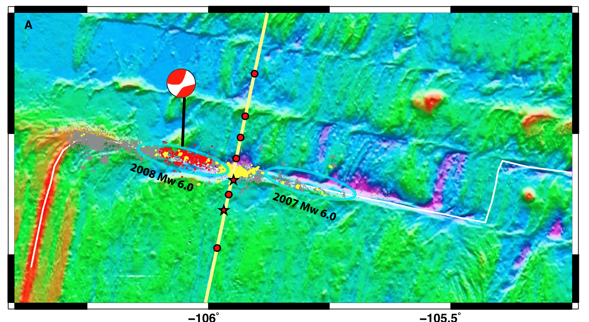


It has been long recognized that a significant portion of strain at mid-ocean ridge transform faults (RTFs) is released without generating large earthquakes (Boettcher & Jordan 2004). Where and how is that strain released? And what controls where large (M6 and M7 earthquakes) do occur? Because many RTFs are located in extremely remote regions of the ocean, these questions were difficult to address until large-scale seismic and marine geophysical experiments started making close-range observations of these faults, providing details on the rupture process of individual earthquakes at individual faults. In 2008 the first Ocean Bottom Seismic (OBS) array observed a earthquake-cycle-ending series of rupture events on the QDG fault system along the southern East Pacific Rise. This experiment – lead by Jeff McGuire at WHOI a close collaborator (and my PhD advisor), helped illuminate a complex process of strain release during the earthquake sequence that incorporated discrete fault segments failing in prolific swarms of microseismic events, accompanied by aseismic slip, that were adjacent to and bounding rupture zones capable of M6 earthquakes (McGuire et al. 2012). A key advantage of studying fast-slipping (<14cm/year full rate) transforms is that they host earthquakes with extremely short seismic cycles, on the order of 5 years, a reasonable timeframe to capture earthquake activity with a short, 1-2 year OBS experiment. ~10 years after the 2008 experiment, a large team of collaborators is working on tackling the next more detailed set of questions related to the Gofar fault. This NSF-funded experiment: Capturing 4D Variations in Stress, Slip, and Fault-Zone Material Properties: The 2019-2021 Gofar Transform Fault Earthquake Prediction Experiment is being lead by Margaret Boettcher at University of New Hampshire and is involving two years of OBS deployments targeting detailed observations of earthquake and physical property information at the Gofar fault during the end of the seismic cycle along one or more rupture zones. Additionally, this experiment will incorporate fault zone rock sampling via shipboard dredging and high-resolution imaging of the seafloor and shallow subsurface using AUV Sentry. A follow up experiment will image the subsurface using EM (lead by Rob Evans at WHOI). The group at WWU will be participating as a member of the PI team and will lead some of the Sentry dive planning, as well as help to synthesize and coordinate seismic observations. Updates to follow as we navigate this three-to-four cruise experiment spanning the logistically challenging 2020-2021 year! Read more about how we think thermal (Roland et al., 2009) and material fault structure (Roland et al. 2012) may be influencing earthquake rupture behavior at RTFs. Figures: On left bathymetry map of the Gofar Fault on the EPR, showing a cross section across the rupture barrier where and earthquake swarm (yellow dots) preceed a large M6 rupture in 2008 (aftershocks, red). Cross section shows the seismic velocity structure from Roland et al., 2012. On right picture an OBS on deck during one of the three long cruises to the remote fauts.