• Reference Maps
  • Table of Contents
  • Download the Data
  • About the Atlas
  • News

Home

Reference Maps

Reference Map for the Salish Sea BioregionReference Map for the Salish Sea Bioregion
https:/Salish Sea Bioregion Physical Geography Reference Map 8x11/wp.wwu.edu/salishseaatlas/files/2021/10/Salish-Sea-Bioregion-Reference-Map-8x11-1.png
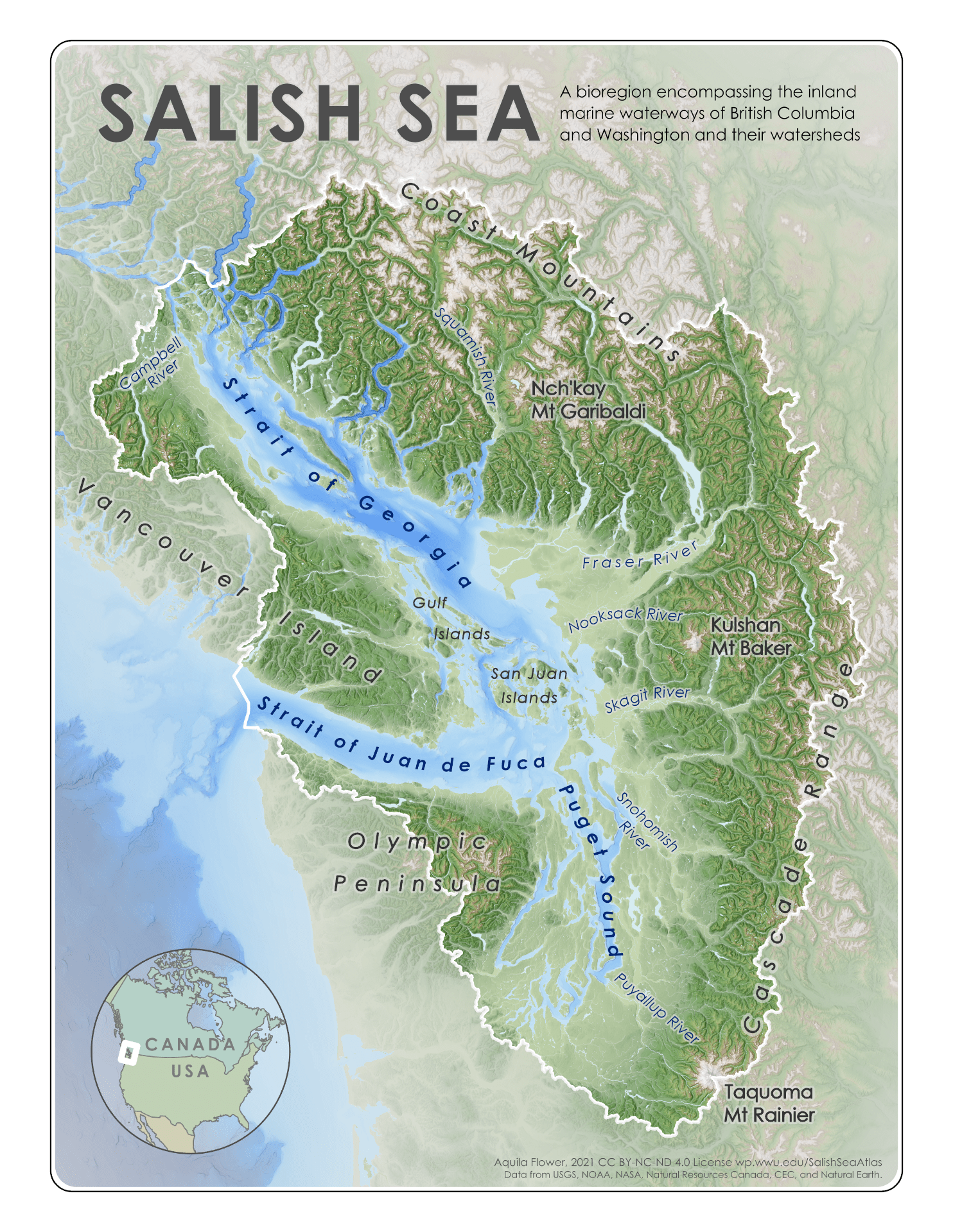
Physical Geography Reference Map for the Salish Sea Bioregion

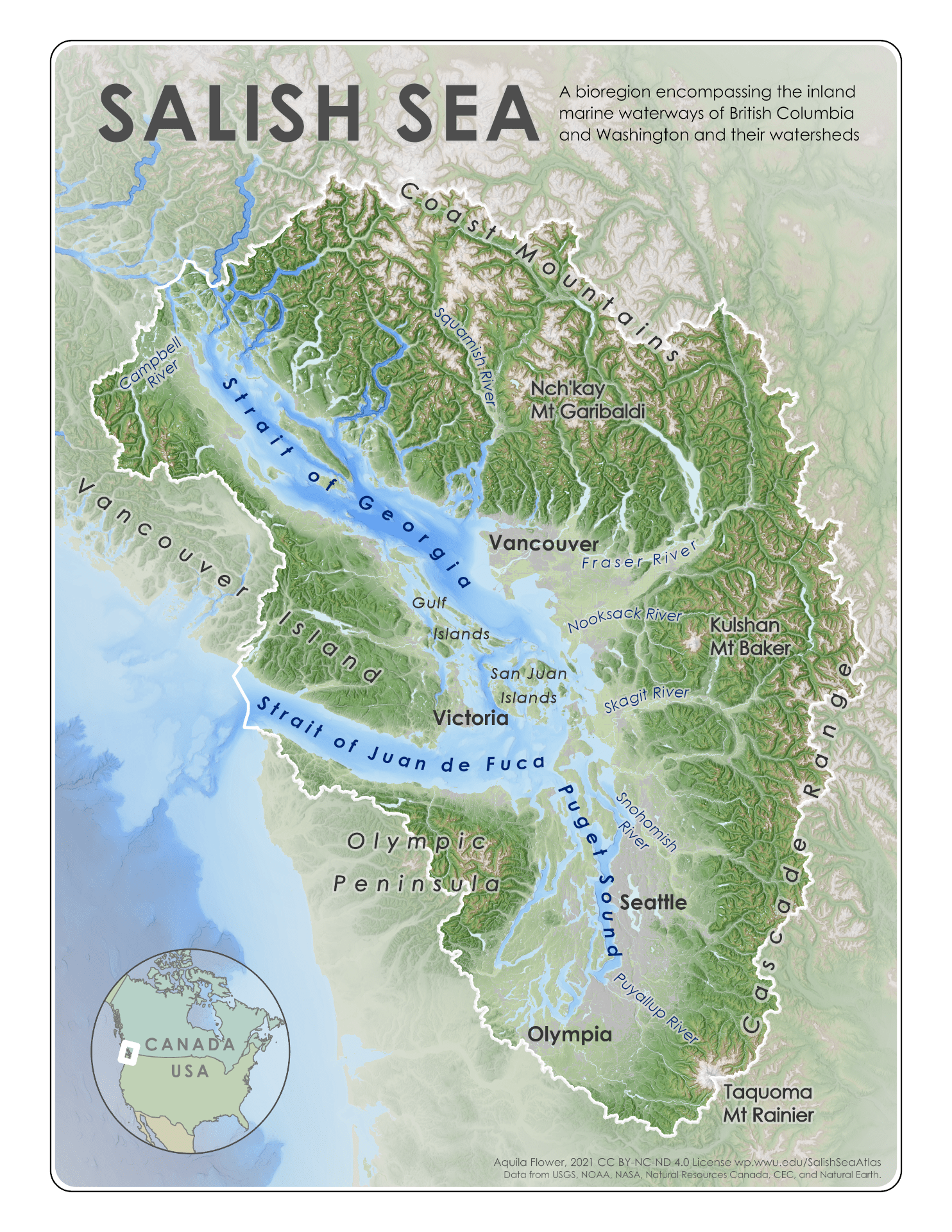
These reference maps show the lands, waters, and urban areas of the transboundary Salish Sea Bioregion. The Salish Sea is an international estuarine ecosystem composed of an intricate network of inland marine waterways in Washington and British Columbia. The Salish Sea Bioregion includes both the marine waters and their upland watersheds.

These maps were made by WWU’s Dr. Aquila Flower as part of the Salish Sea Atlas.

+ Credits and License

These maps were created by Aquila Flower with support from Western Washington University’s Spatial Institute, Salish Sea Institute, and Border Policy Research Institute.

This work is licensed under a Creative Commons Attribution-NonCommercial-NoDerivatives 4.0 International License. You are free to share and distribute these maps for non-commercial purposes, but you must include a citation (such as “Reference Map for the Salish Sea Bioregion, Aquila Flower, 2020″). If you wish to modify these maps, you can do so only with prior permission.

+ Data Details

Bathymetry and elevation data from multiple sources were combined as a mosaic to create a single cohesive topo-bathymetric model of the region. The boundary of the Salish Sea Bioregion follows the outline of watersheds that drain into the sea. Throughout most of the region, the boundary exactly follows the borders of HUC-8 level US watersheds and sub-sub-drainage basin level Canadian watersheds that directly or indirectly drain into the Salish Sea. Watersheds in the Fraser River’s upper drainage area were excluded. The watersheds at the northeastern and northwestern corners of the boundary were clipped along sub-basin boundaries to remove portions of the larger watersheds that drain into Johnstone Strait rather than the Salish Sea.

Dataset Source Data type
Elevation NASA Shuttle Radar Topography Mission 90 meter resolution raster
Bathymetry NOAA U.S. Coastal Relief Model 90 meter resolution raster
Bathymetry NOAA British Columbia Bathymetric Digital Elevation Data 90 meter resolution raster
Hydrography – US USGS National Hydrography Dataset Vector lines and polygons
Hydrography – Canada Natural Resources Canada National Hydro Network Vector lines and polygons
Urban land cover The North American Land Change Monitoring System 30 meter resolution raster
Coastline – US Washington DNR ShoreZone Vector lines and polygons
Coastline – Canada GeoBC Freshwater Atlas Vector lines and polygons

+ Download the Maps

SalishSeaBioregionReferenceMaps.zip

This .zip folder contains 300 dpi PNG format files of the Salish Sea Reference Map and the Salish Sea Physical Geography Reference Map in 8.5×11″ layouts.